Author Archives: dave

Saskatchewan River Crossing to Jasper

July 21, 2010 – 97 miles

We started our day with a buffet breakfast. Knowing I had nearly 100 miles to Jasper, I made an effort to load my stomach. It’s another sunny day, but very cool and crisp.

IMGP1965

After turning onto the highway, we rode in the shadows of the mountains. The first few miles were generally downhill and VERY cold. Even still, I wore only my SmartWool long-sleeve shirt on my upper half.

IMGP1967

As I rode, I noticed faint lines and numbering spray-painted across the shoulder. The numbers seemed evenly spaced and slowly counted upward. After a few miles, I realized the marks were painted every 400 meters, roughly. Now that the lines were in my mind, I couldn’t NOT see them. Great, I thought. I’ll spend the rest of the day counting quarter miles up to 400! Maybe the lines stopped or maybe I got distracted, but I eventually stopped noticing.

After a few cold miles, I finally reached the sun. How great it felt!

IMGP1969

It’s funny how much of an opposite extreme this is from day #1 in the desert south of Hachita, NM. There, I had no shade. Now, I appreciated it’s warmth more than ever.

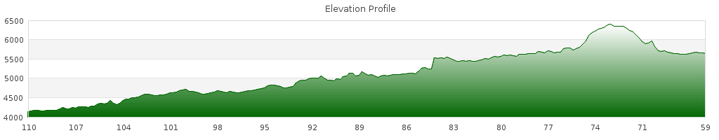
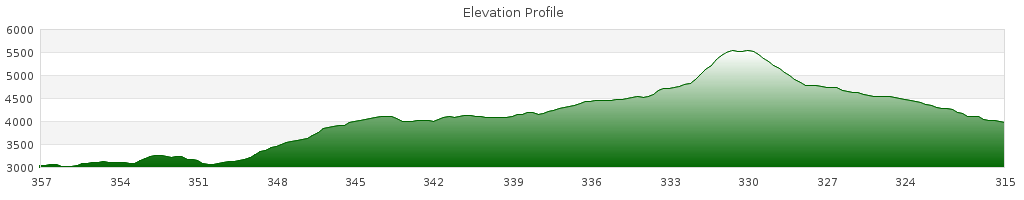
The road dropped toward a wide river and started following it upstream. Soon, I started climbing up and away from it. Across a bridge overlooking a waterfall, and then further skyward.

IMGP1979

The climb lasted about 8 miles. I made it most of the way without resting, except the last few miles. Near the top, I was passed by a group of touring cyclist heading downhill. My time will come, I thought to myself.

IMGP1980

IMGP1982

I don’t know what time I reached the Columbia Icefield, but it must have been close to noon. There’s a restaurant there that resembles an airport. Except instead of airplanes, buses were constantly coming and going. I knew it is a tourist trap, but I went in for a meal anyways. Overpriced, but what did I expect.

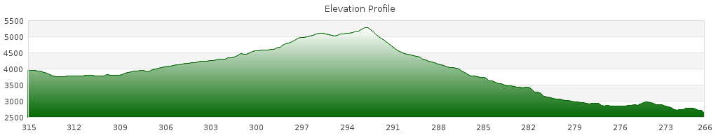
After lunch, we continued riding along a river. It must have been a different river, because we were following this one downhill, now. We had 60+ miles left to Jasper, but knowing it was generally downhill was a mental boost.

IMGP1985

Shortly after lunch I reached the fastest speed of the entire trip – 42.1 mph! That’s pretty fast considering I’m riding on knobby tires and have two large panniers up front making me as aerodynamic as a snowplow.

The grade flattened eventually and I resumed trudging along. As the miles wore on, I noticed my butt getting more and more sore. I was getting tired and put more weight on the saddle. Unfortunately the shoulder seemed to be degrading. Every 10 feet there was a large crack in the pavement. Thump thump. Thump thump. Thump thump. Each one rubbing my butt a bit more raw. I contemplated riding in the traffic lane, but the dangerous RV drivers kept me away. I stopped often to apply ointment, but it only ever temporarily helped.

30 miles after lunch, I stopped at a shop near Sunwupta Falls. I saw Mathieu’s bike there and figured I could use a break from the saddle. I ate a brownie, cheesecake, and a gatorade. Anything to ease the suffering in my behind.

After the short break, I saw rain clouds rolling in from the East. I sped up, hoping they’d pass behind me. Lucky I didn’t go too fast, because a few miles later I was riding on wet pavement. It had been raining there just a few minutes beforehand.

A roadie passed me up, while I was climbing a small hill. I later caught up while she was talking to someone in a car she apparently knew. “Where’d you start,” she asked. What to say? There are so many options. “Mexico” and on I rode.

She later caught up with me and asked where I started today. I told her Sascatchewan River Crossing – today’s a long day. Telling her I’d already done 100+ km today seemed to have more of an impact than the 2900 miles beforehand.

She rode ahead and I was alone on the rode. That’s how I’d prefer to ride my last miles – alone to let individual experiences come to mind.

I rode onwards and occasionally glanced at my odometer. Am I really about to finish this trip? Nearly 3,000 miles on the odometer with 10 to go….5 to go…2 to go…

I spent those last miles singing the songs that got me through tough sections in the past. I’m not struggling now and I don’t need the distraction….I’m reminiscing.

I switch on my helmet cam to capture the last moments of my ride. Smooth pavement and traffic – this is not representative of my trip at all.

I ride into jasper and it’s over. Just like that. The last day was the longest – 97 miles by my odometer and I still have juice in my legs.

We checked into a hotel, shower and go to have dinner. Baked spaghetti is what I order, except it’s not as good as I imagined.

Back in the hotel, I flip on the CNN – race issues, the oil spill, celebrity happenings. I didn’t miss this at all.

Before I go to bed, I realized tomorrow I won’t have to wake early. I won’t have to ride from 9 to 5. Tomorrow the rhythm of the past two months will be broken.

Lake Louise to Saskatchewan River Crossing

July 20, 2010 – 50 miles

We rose to another very beautiful morning.

IMGP1944

After a short stretch on the Trans-Canada Highway, we turned onto Highway 93. It had a good shoulder, but cars and RVs didn’t move over much. The road had a rumble strip dividing the two lanes of traffic.

IMGP1945

IMGP1949

We climbed gradually for the first 30 miles of the day to Bow Pass. Along the way I passed a group of bike “tourists” – the folks that are shuttled to Point A and picked up at Point B (point B being mostly downhill). I thought back to how I was first introduced to the crazy notion of living out of bags attached to your bike. I was one of those tourists in Alaska and I saw a man pedaling up the pass I was cruising down. The tides certainly have turned.

IMGP1952

IMGP1953

IMGP1956

I caught the group on one of the climbs and made it my goal to surpass them. Their lightweight road bikes were no match for the thousands of miles in these legs. I proudly passed them with ease! Later I even passed other recreational roadies. I was proud that my legs had powered me though so much.

At the top of Bow Pass, I was treated to an amazing view. I could see for a vast distance through the valley in front of me.
IMGP1957

We encountered sporadic showers during the last 20 miles, but nothing as serious as yesterday.

IMGP1961

IMGP1962

We arrived at Sascatchewan River Crossing and found it to be a tourist trap. It wasn’t a town at all – just a motel, restaurant, and gas station. We ate a late lunch/early dinner at the restaurant. It was all horribly overpriced.

A hailstorm rolled in and we decided to stay the night in the hotel. The rooms were expensive and bargaining wasn’t getting us anywhere. Finally the desk clerk offered us $20 off if we took a room that shared a wall with the bar (with live music late at night). We were glad to take it!

We went back to the restaurant for a buffet dinner. Although it was expensive, we ate our fill. I made sure to eat extra food as fuel for tomorrow’s ~100 mile ride to Jasper.

Banff to Lake Louise

July 19, 2010 – 40 miles

Although the Great Divide is finished, Mathieu and I are continuing North to Jasper. The route is paved the whole way and passes through the Ice Field Parkway – possibly the most scenic drive in Canada.

It’s roughly 200 miles from Banff to Jasper, and our first stop, Lake Louise, is only 40 miles away. On pavement and without any monstrous climbs, we decided to start the day very slowly. Upon waking, we found a laundromat and cleaned our clothes one last time. While waiting we went to Timbers again for breakfast. I had the same meal as yesterday but with extra hash browns. Afterwards we went to a grocery store to stock up for the next three days.

Afterwards, we went back to Bumper’s to pack up. Just before leaving, I noticed my front tire was feeling a bit flat so I decided to change the tube. I pumped the new tube up to its maximum pressure – we’ll be riding on pavement, so I want them as efficient as possible.

We left Banff at 13:00 – just as some threatening clouds rolled in. Not 10 minutes later, it started raining. It wasn’t a pleasant summer sprinkle, either. It was coming down cold and hard. For two hours we suffered through the cold and the wet. Ironically this was the most rain we rode through on the entire trip!

The scenery wasn’t too great, but I did see a moose near the road. Of course, there also were a few dozen motorists idling nearby with their heads and cameras sticking out the car windows. Someone in the car ahead of me clearly wanted a picture and slammed their brakes, almost sending me into their rear. Ugh. Now I remember what it’s like to ride with cars.

Although the distance and elevation gain indicated an easy day, the rain made it tiring. We decided against camping in this weather and procured a hotel room for the night. After dinner the clouds gave way to sun and we got a peek of the glaciers above us.

IMGP1943

Looking at our maps we realized there we miscalculated the mileage for the next two days. Instead of the next to days being split 50%, tomorrow would be relatively short followed by a near-100 mile stretch to Jasper.

Banff Rest Day

July 18, 2010

We awoke and slowly packed up from our campsite. Our first priority of the day was food. I had an amazing breakfast at Timbers – Eggs Benedict with salmon, a size of pancakes, and the best hash browns I’ve ever had. Afterwards, we rode through town to see if any hotel rooms were vacated. We reserved one at Bumper’s Inn (at the far North side of town) for a decent rate. I spent much of the day strolling around town and trying to get caught up in my journal.

We had a proper celebratory dinner at Bumper’s Inn restaurant. They are known for their beef so I ordered a huge steak.

Lower Kananaskis Lake CG to Banff

July 17, 2010 – 63 miles

This morning was my last on the Great Divide. I started the day right with a steaming bowl of Mac N Cheese. We packed our gear and pedaled out of camp one last time. The weather couldn’t be better. Clear skies and fair temps.

IMGP1910

IMGP1911

IMGP1912

IMGP1913

After a short stretch on pavement, we turned onto a gravel road. At first it was very loose – the kind of gravel that makes it too easy for your wheels to slip out from under you. The road hardened after a few miles and the traffic increased. The area along the Smith Dorrien Spray Rd is a destination among motorists.

IMGP1915

IMGP1916

IMGP1920

Aroud 13:30 I reached the Mt. Shark trail and found Mathieu waiting. Some curious backpackers came over and started chatting about our trip. I remember talking to people and telling them it was day #1 or #2 back in New Mexico. At the time, making it this far was an uncertainty.

Mathieu wanted to keep riding so we left the backpackers behind. We had 8 hours of light left, but he was worried the trail ahead might make for slow riding.

The trail was indeed slow riding. At first it was a series of short/steep ups and downs. I thought it was a fun ride. Eventually, the trail became narrow singletrack – with front and rear panniers, it was difficult.

The trail spilled onto an un-maintained forest road, but the riding still was slow. We pushed our bikes over multiple downed trees.

Our hurry to make mileage meant we delayed lunch. It was pushing 15:00 and I hadn’t stopped for a substantial meal since breakfast. I was growing hungry to the point of bonking. After pushing up one last steep section of the forest road, I started skirting Spray Reservoir. The spectacular view distracted me from the discomfort.

IMGP1921

IMGP1922

IMGP1923

IMGP1926

Soon I reached the Spray Reservoir Dam and Mathieu was there. I knew it was time for me to eat. Tortillas with tuna and tortillas with nutella. I had packed along a package of chocolate pudding and decided it might help give me more energy. Unfortunately, I hadn’t read the package carefully – it needed to be cooked.

I didn’t want to mess with my stove, so I drank a gritty mixture of water and pudding mix. Despite a slightly displeasing texture, it gave me the energy I needed. I certainly was riding faster with food in my belly.

IMGP1928

IMGP1931

IMGP1935

We crossed the dam and continued toward Banff. We rejoined Smith-dorrien road. There was more traffic than before and the amount of dust had increased. Not to mention horrible stretches of washboard.

Finally, we reached the Goat Creek Trail – the last 12 miles of the Great Divide.

The trail once again consisted of fun ups and downs. I was tired and my butt hurt, but I felt good. My goal of reaching Banff was so close that it didn’t bother me.

8 miles from Banff, I met a solo SOBO rider. I wasn’t in a hurry and decided to chat. He had started this morning and had traveled those 8 miles in 5 hours. He was 58 years old and not in the best riding condition. He had two months to ride the trail. How far he’d make it, he didn’t know. And after his first day he wasn’t sure if he’d continue much further.

I tried to encourage him. I was in the same situation 6 weeks ago in New Mexico (although I had “youthful hubris” on my side).

IMGP1938

I wished him luck and continued North. As I came nearer to Banff, I flipped on my helmet cam to record my accomplishment. The Great Divide must have felt my cockiness. Whenever I thought I was done climbing, another short/steep hill would appear. I no longer though of these hills as impediments, but rather like opportunities to test my strength. I tackled them like a pro.

Suddenly – I turned a corner and rode into a parking lot. It looked familiar – I had seen it before in youtube videos and personal accounts of other Great Divide riders.

I was done with the Great Divide.

As always, Mathieu was patiently waiting for my arrival. We took some photos in front of the HUGE Banff Springs hotel.

We rode through town to find a place to stay – it was very crowded and filled with traffic. I felt like an outsider – dirty, smelly, and weathered among the well dressed folks strolling though town.

It was a Saturday night and all the hotels were booked or overpriced. $300+ for one night! Then again, if I were a receptionist at a hotel, I might night want folks like me to dirty up one of their prestigious suites.

It was getting very late so we rode to a campground on the opposite end of town. It disappointing to . We weren’t welcomed like celebrities as we might have subconsciously hoped.

When we reached the campground (which, of course was seated well above city level) it was dark. We pitched tents, took quick showers, and changed into street clothes. We rode back into town for our well-deserved celebratory dinner. Unfortunately, by the time we got there it was 22:30! Maybe eating a late lunch was beneficial.

I ate a bowl of spaghetti at Giogrios. Mathieu had a pizza, which seemed a bit stale. We left and climbed back to our campsite in the dark. It was midnight by the time I collapsed in my tent.

After riding around looking for a hotel and going back and forth between the campsite and restaurant, we put an additional 17 miles on our odometers! This wasn’t the greeting we expected from Banff.


Stats
Distance: 59 miles
Ascent: 4331 ft
Descent: 5358 ft

Elkford, BC to Lower Kananaskis Lake Campground, AB

July 16, 2010 – 51 miles

The paved road out of Elkford faded to dirt rather quickly. No need for it to be paved as it essentially leads to nowhere. 40 miles ahead, the road crests Elk Pass – the final Continental Divide crossing which will bring us to Alberta. Vehicles are not allowed over the pass, so I don’t expect there to be much traffic.

A few miles into the ride, I got the feeling that my front tire was low on pressure. Once the notion was in my head, I couldn’t get rid of it. I stopped to give the tire a squeeze and it felt properly inflated. After riding a bit more, the feeling came back. I laid down the bike and checked the pressure with my pump. The gauge read a normal pressure, so I rode on.

Up and down little roller coasters we went. I didn’t enjoy repeatedly climbing 100 ft then dropping 80. All I could think of now was the needless elevation gain and loss.

We stopped for lunch at the Weary Creek Recreational Site – basically, a table, fire pit, and tent clearing – along a fast-moving river. Shortly after leaving, it started raining intermittently.

IMGP1895

IMGP1896

IMGP1893

It started absolutely dumping rain just as I rode past a Forest Service cabin. Mathieu and I waited out the weather under the shelter of the cabin’s front porch.

IMGP1897

IMGP1899

IMGP1904

After the rain let up, we rode a short distance to the start of the trail that crests Elk Pass. I found it to be very steep and pushed a lot past the first half-mile.

As I was pushing my bike out of the woods and into a clearing, I heard the sound of munching grass to my left. I couldn’t see, but it sounded like cattle. I pushed past some bushes and saw a large bear.

Bear!

He didn’t notice me, so I took the bear spray out of the camelbak shoulder strap holster and removed the safety wedge. It was only now that I realized how slowly I managed to arm myself with the bear spray.

With the bear spray in hand, I turned on my helmet cam. I figured it might make good footage if the bear charged and I heroically defended myself.

IMGP1907

I pushed my bike into the clearing and the bear finally realized my presence. I yelled “Hey. Get outta here,” but the bear wasn’t scared. He just looked at me and continued to eat grass. The bear was collared and had a weary look to him. He’s seen humans before, I guessed. I took a few pictures and continued walking my bike up the pass, often looking over my left shoulder.

I found Mathieu at the top and recalled my bear encounter. He was only a few minutes ahead of me but had not seen the bear.

Now in Alberta, we descended along the power lines to Kananaskis Lake. We saw another bear scamper into the woods as we rode past. I’m glad we’re staying in a campground tonight, not wild camping in the woods.

IMGP1908

We ate a meal at the Boulton Creek Trading Post before finding a spot in the campground. We were now in an area with road access, and the campground was very busy.

As the sun set, I cooked a bowl of Mac’n’Cheese in celebration that tonight was the last night on the Great Divide.


Stats
Distance: 51 miles
Ascent: 4829 ft
Descent: 3329 ft

Fernie to Elkford

July 15, 2010 – 50 miles

Today, we started with 20 paved miles to Sparwood. A strong tailwind made them fly by. In Sparwood, we ate lunch at a pizza place near the world’s largest truck.

Supposedly this is the most photographed “landmark” on the Great Divide:
IMGP1881

World's Largest Truck - Sparwood, BC

After leaving Sparwood we rode on quiet paved side roads though mountain-surrounded fields.

IMGP1886

IMGP1884

We eventually turned off our peaceful side road onto a quieter dirt road near a mine site, climbing gradually. The mountain scenery made for a good distraction from the ascent. After a very rocky section at the top of the climb we descended.

Just outside of Elkford, we passed a coal processing plant. The towering factory, blackened from soot, stood out sorely against the pristine backdrop. Clean coal…what a joke! The forest around the plant and road were completely cleared.

The final descent into Elkford was scary – steep enough that there were runaway truck ramps along the way!

In town, we went to the library and used the computers to take care of our blogs and picture uploads. We left when the library closed and searched for a place to stay. All of the hotels were extremely expensive. We found one anyway.

The next order of business was dinner. We rode out of town to a restaurant. Mathieu was smart enough to have detached his trailer. We climbed a few hundred feet to get to the restaurant – and I still had my panniers with me!

Outside the restaurant we met a man smoking outside. His shaggy appearance made him look homeless (though I’m not in a state to judge). He followed us inside as we sat down at a table and invited himself to join us. That was just the beginning of the oddness of our new meal-friend, Paul.

I wish I had a tape-recorder with me to catch some of the things Paul said. Drunk – no. Crazy – very possible! He repeated phrases like “The sun rises in the east and sets in the west. Air is free. Breathe it in. Air in the blood…makes the brain work” and “blow-my-nuts.” He was about to inform us about what a “fuck circle” was before he was interrupted with a phone call.

Paul told us of the RV park he owns and the large plot of land on which he is installing sewer lines (so he can sell it for development). When our checks arrived, our friend grabbed them, paid our bill, and walked out. Over an hour, my impression of this guy went from dirty homeless man to crazy millionaire.

Mathieu and I stopped at an ice-cream place before riding back to our hotel. On our way back, though, Paul drove ahead of us like a lead car. He invited us to join him at the bar. We said we were going to take showers before joining him, but that was a lie. Neither of us felt like joining crazy John at the bar.

Eureka, MT to Fernie BC, Canada

July 14, 2010 – 57 miles

I didn’t feel too hot this morning. My lungs felt full of phlegm and my throat was sore. I put it behind me as I pedaled along a quiet road to the Canadian border.

The border crossing was painless – I’m sure coming into the United States would be much harder.

In Line for Canada

The southernmost section of Canada’s Great Divide mostly followed along highway 93, except that it sporadically zig-zagged along neighboring dirt roads. I decided that extra fuss wasn’t worth it, so I just rode on the pavement. After all, there was little traffic and the shoulders were quite large. Mathieu decided to zig-zag on the dirt roads. We agreed to meet at the Dairy Bar near the town of Elko.

IMGP1875

I guessed that my route was 5 miles shorter than Mathieu’s, but I rode hard enough to make sure I’d get there before him.

At the dairy bar, I ordered two excellent milkshakes and a burger. Right after eating, though, my chest pain came back. While we were getting ready to leave, a SOBO GD rider pulled up. His journey just started – ours was all but over. He asked if we had any advice for the coming 2,500 miles. Just like yesterday, I didn’t know what to say.

We left the Dairy Bar and turned off to a dirt road following a river on the opposite side of highway 3. The sun was strong and there wasn’t much of a breeze. I started sweating, which for an unknown reason made my skin feel very itchy. I would understand if my face itched from being wind-burnt during yesterday’s cold descent, but it was my entire body. Sun poisoning didn’t seem likely either since I’ve been wearing long sleeves every day.

Despite being very uncomfortable, I rode onward.

IMGP1879

IMGP1880

I eventually made it to Fernie without incident. At times the backroads were difficult to navigate, but dutifully watching the odometer removed all uncertainty. In town, I set out to find Mathieu. I rode down the main street to the north edge of town without seeing any sign of him. I rode back and decided he hadn’t arrived yet. Naturally, I parked my bike outside the Subway in town and went inside for an early dinner. I received an important cultural lesson when ordering my sub. In the States, we’re offered “American cheese” on our sandwiches. Not in Canada, though. Here it is “white cheddar,” which makes more sense. What makes it “American?”

When Mathieu rode up to the Subway 45 minutes later, I knew something was wrong. His arm and leg was bloody. He took a wrong turn some place and climbed uphill a number of miles before realizing his mistake. Along the way he had a fiasco with his trailer – I don’t know how, but he said it pulled him to the ground. Outside, he showed me a very out-of-true front wheel. It must have been quite a fall to do so much damage!

We finished our subs then rode through town, shopping around for the best hotel rates. I spent the night trying to update my journal, while Mathieu flipped his bike and tried to true his wheel.

Polebridge to Eureka

July 13, 2010 – 58 miles

Today started with 6 miles of terrible roads to rejoin the main route. Mathieu realized he left his odometer in the Hostel and turned back to get it. I continued at a comfortable pace.

We met a solo southbound rider who left from was on day #2 of his trip (he started on the US border, not Banff). He informed us that the roads ahead were good. (Later, we decided he must have a different opinion of what “good” means.)

IMGP1865

After an hour or two of riding, I was stopped by a family in a car. They were curious about what I was doing and amazed when I told them. They asked a question I wasn’t prepared for – “What has been the highlight of the trip?” I didn’t know. Every day has had its highs and lows, struggles and accomplishments, euphoria and mental fatigue. In a week when I’m in Banff I’ll have the time to think back.

A bit later I met a waiting Mathieu. We had 14 miles to go to the Whitefish Divide. We agreed that Mathieu would wait at the top unless the weather turned sour. We departed together, but after a few minutes I was already riding alone.

I passed through a vast burn area.

IMGP1867

IMGP1869

The overcast sky, cool weather, and lack of leaves made it feel like late fall, not the middle of summer. Riding through it gave me an eerie feeling. I was glad once I was riding again in living forest.

IMGP1870

IMGP1871

The climb up the Whitefish Divide was gradual, but rocky. When I reached the top, I saw that Mathieu had already gone. I cannot blame him. The wind started to pick up and the temperature dropped. The sky threatened rain or snow.

I layered up for the descent – winter hat, gloves, fleece, rain jacket, and rain pants. The descent turned out to be very rocky and forced me to go very slow. The last thing I wanted to do, though, was stay on this descent for longer than necessary. The gravel road eventually spilled onto a stretch of fresh asphalt. It was so smooth that my handlebar-attached bear bell was not vibrating.

As I was descending this winding road, I rounded a corner and saw a bear jump out of the shrubs on the left side of the road – 40 feet away. I pulled the brakes hard and skidded my rear wheel. Until then it had not noticed me.

When it did, it looked and paused. “Fight or flight?” It decided to turn heel and run. It must have been my grizzly beard that scared it away (or the fact that a scrawny biker wouldn’t be much of a meal).

As the bear turned to run, I reached to my helmet cam & flipped it on just in time to get a few frames of it.

In hindsight, maybe it would have been smarter to reach for my bear spray instead of the camera.

A few minutes later, I saw to southbound riders. They shouted out asking if I was on the Divide. Unfortunately, they couldn’t stop. Following 100 meters behind them was a convoy of road construction equipment. If they were overtaken, they’d be breathing in fumes for the remainder of the paved climb. I didn’t even have a chance to warn the riders of the bear I just saw.

Once the descent leveled out into flat farmland, I shed my warm layers and continued on Tobacco Rd – a quiet road paralleling US 93. I rode into Eureka and found Mathieu’s bike outside the library. I uploaded some photos while he updated his blog. We went to “Papa’s Pizza, Grandma’s Goodies” and each ordered a HUGE pizza. It was too greasy for my taste.

We rode North of town to the Ksanka Motel – only 9 miles from the US/Canada border. I thought about how odd it would be to finish the trip at the border. Especially with the beautiful Canadian Rockies just ahead. As I lay in bed that night, I had a realization that my trip actually is coming to its end.


Stats
Distance: 52 miles
Ascent: 2869 ft
Descent: 4192 ft

Whitefish to Polebridge

July 12, 2010 – 50 miles

We rode on pavement out of town along Whitefish Lake. It reminded me a lot of Lake Paw Paw in Michigan were I spent a lot of summer weekends at my grandparents lake-house.

The pavement ended after 10 miles. As we started on the dirt road, a cherry red Corvette followed slowly behind us. Once again, I was proud to be on the mountain bike, not in a mid-life crisis vehicle.

IMGP1846

We passed through some old burn areas and started climbing toward Red Meadow Pass. After 15 miles of gradual climbing we stopped for a quick lunch. The sky looked as if a storm may come soon.

The steepest three miles to the pass lay ahead. Overall, the climb was not too difficult. But there were a few short 100-ft sections that were just too steep for me to climb. So I resorted to pushing. Even after 6-weeks of riding, the Great Divide was still forcing me to walk!

IMGP1849

At the top was a beautiful lake. The mosquitoes were hell, though
IMGP1850

IMGP1851

As I started descending, the sky turned more threatening.
IMGP1852

The backside of the pass was a fast descent through pine forest.

IMGP1855

After a while, we turned off-route to go to the town of Polebridge. Here, we encountered the worse roads so far. Imagine paving a road with cement. Before the cement dries, drop baseball to basketball sized rocks into the cement and let it dry. This road was worse than riding on washboard! The rocks absolutely killed forward momentum.

After 6 miles we made it to Polebridge. My first stop was the bakery in the Polebridge Mercantile. They had dozens of different breads to try.

We rented bunks at the North Fork Hostel – a unique off-the-grid cabin. Oliver, the current owner, retrofitted the cabin with composting toilets, a green house, and solar panels. They even offered Wifi!

IMGP1859

IMGP1861

We went to the local restaurant for burgers and sodas. Again, I was plagued with stomach and chest pain. I forced myself to eat, though. I’d pay for it worse on tomorrow’s ride if I didn’t eat properly today.


Stats
Distance: 41 miles
Ascent: 3881 ft
Descent: 2963 ft