Author Archives: dave

Whitefish Rest Day

July 11, 2010 – 0 miles

This morning we decided to head to the library to update our blogs and upload pictures, so we walked into town. The library was closed but the wifi was still on, so Mathieu did some blog maintenance on his iPod Touch. I walked around town looking for coffee shops with public computers. I didn’t find any, so I picked a shop and wrote in my journal while sipping a large coffee.

After a while, I left and went back to our hotel. The World Cup Finals was about to begin. Normally, I wouldn’t watch the game, but I did since the Netherlands was in it.

We went to a local supermarket before the game started to get some food to eat during the game. I brought back way too much food – a pound each of macaroni salad and potato salad! By the time the game was over, I had finished my salads and started to feel like crap.

We went out to a pizza place for dinner, but I did not order any. The heat of the ovens emanated through the entire restaurant. Standing in line with Mathieu was unbearable, so I sat on the sidewalk outside. I cursed my stupidity for eating so much.

After dinner we walked back to the hotel and worked on our bikes until the sun went down. It took a long time to fall asleep. My stomach and chest hurt all night. I’ve never had heartburn before, but I think that is what it was.

Update to EatSleepRideGreatDivide.com

I’ve just released an update to EatSleepRideGreatDivide.com that I think is pretty cool. In addition to showing detailed elevation profiles of the route, riders carrying a SPOT tracker can add their ride information (blogs, etc.) and have their position shown on the map. You can also view a rider’s multi-day trail with a profile and ascent/descent statistics of the terrain they covered.

Those sitting at home can follow along and see who’s where and read up on their adventures. Those en-route can look ahead to see where other riders are (when in town).

So, if you’re riding the Divide this year and carrying a SPOT, add your information to Eat. Sleep. Ride. Great Divide. Give me and the other superfans out there the pleasure of living vicariously through your adventures.

Swan Lake to Whitefish

July 10, 2010 – 70 miles

I woke up feeling great this morning. We rolled out of camp after cooking breakfast on the bunk’s porch and eating cinnamon rolls & coffee with our hosts.

There would only be one climb today, and it started just a few miles into the day. I was feeling great and found the Zone. I made it up the 1800 foot ascent without pause. The backside was a rewarding smooth descent that allowed us to enjoy considerable speeds. The road turned into pavement, and that was the last we saw of gravel for the day.

We continued on rolling hills into Swan River, where we ate lunch at a crowded restaurant. Afterwards, the route had us follow a tedious sequence of roads on a tetris-like grid. We decided we’d make it to Columbia Falls by our own route-finding. The directions were too difficult to decipher in reverse.

I convinced Mathieu that we should ride down certain low-traffic road to get to Columbia Falls quickly. We did, but the road type unfortunately was mislabeled (it was not a county road, like I expected). The road was narrow and the traffic was fast and dense. Mathieu plowed ahead, though. At one intersection, we were given opportunity to rejoin the official route (which I assume was lower traffic), but Mathieu passed it without noticing. I wanted to return to the route, but we’d probably end up separated. So I continued on the busy road to catch up to Mathieu.

Columbia Falls was looked gray and rundown so we rode through without stop. Only a few more miles to Whitefish.

Whitefish turned out to be larger than I expected. It was a ski resort town right on a lake. With such venues comes tourists and expensive hotels. We searched for a place with vacancy for over an hour until finally finding something. We moved into the Whitefish Hotel for the next two nights. It was a dump but without a proportional price.


Stats
Distance: 62 miles
Ascent: 4192 ft
Descent: 4349 ft

Holland Lake to Swan Lake

July 09, 2010 – 55 miles

We met more SOBO riders on today’s section.

IMGP1845

Jazz & his uncle were riding from Banff to mi-Wyoming. Jazz was the youngest rider we’d seen on-route. His uncle is planning to ride the 2011 Tour Divide.

Later, we met a pair on a mountain bike tandem. I didn’t even know tandems were made with suspension.

IMGP1844

We found a shady spot for lunch on the side of a dirt road. The sun was intensely hot that any body part exposed to it instantly felt burning. We ate quickly because the our shady spot was slowly shrinking to nothing.

Down the road, we reached another difficult section to navigate. Again, the cues could be read more than one way. We took a wrong turn and climbed a few hundred unnecessary feet.

As we neared Swan Lake, I caught up to Mathieu who was stopped in the middle of the road. He was watching two black bears 50 yards ahead. My approach scared them off, though.

At Swan Lake, we rented a cheap bunk house to spend the night. The price included a well-deserved shower. I stayed up late in the mosquito-proof cabin updating my journal by headlamp.


Stats
Distance: 50 miles
Ascent: 3286 ft
Descent: 4225 ft

Ovando to Holland Lake

July 08, 2010 – 58 (+10) miles

This morning I ate a hearty bowl of Mac ‘n Cheese for breakfast while Mathieu ate in the cafe. He though I missed out because it had a lot of character inside.

On the road, he asked how I felt. Not bad, but not great. He rode ahead. I assumed he’d wait for me at one of the critical navigation points. Little did I know I wouldn’t see him for another 10 hours…

On a climb, I met a group of 12 southbound-ers who started at Roosville together. During the past day’s, Mathieu said he was looking forward to meeting them as he considered riding with them before deciding to start in Antelope Wells. We talked for a while and I found out they hadn’t seen Mathieu yet. Strange, because last I saw of him he was ahead.

IMGP1816

IMGP1817

The group advised me not to ride solo the Richmond Peak Trail – a rare piece of singletrack on the Great Divide. They reported seeing fresh bear scat and having to lug their bikes over many downed trees.

Should I heed warnings and bypass the trail (which was also at the top of a large climb)? Where was Mathieu? Should I wait for him – or was he far ahead of me and happened to miss the southbound riders?

IMGP1818

I rode onward. All I knew was Holland Lake was our destination…so that’s where I would go.

I stopped for a lunch at a forest road junction. Here I could choose to continue up to Richmond Peak or bypass it on pavement. I ate slowly to let Mathieu catch up in case he was indeed behind me somewhere.

IMGP1819

Enough time had passed without sign of Mathieu so I continued on-route towards Richmond peak. The first five miles were gradual, followed by six steep miles. More than once I doubted my decision to go this direction.

IMGP1821

On the ascent, I met two more SOBO riders.

IMGP1822

IMGP1826

At the top, I reached the Richmond Peak trailhead.

IMGP1828

The trail was very narrow. I didn’t like being so closed in in an area where I knew bears were.

IMGP1830

Contrary to my expectations, the trail still ascended. It made singing for bears very difficult.

IMGP1831

IMGP1832

Obstacles of the Richmond Peak Trail

The trail turned into two-track, then into a regular dirt road, and I started descending finally. On the way down, I passed an abandoned truck with the hood up and jumper cables resting near the engine. Was the driver eaten by a bear?

A ways down the mountain, I found the driver and his dog. He left the radio on while feeding his dog and came back to find the battery dead. He was walking to a the main road. I offered food and water, but the guy was well prepared and didn’t need it.

At the bottom of the steep descent, I stopped to eat a pop-tart. Right then, Mathieu appeared from around a corner where I just came. He didn’t look happy. He said he missed a turn and rode 10 miles before a dead end told him he’d missed a turn somewhere.

IMGP1843

We rode together from then on. Rounding a corner, I saw a small black bear scurry away into the forest. Even riding together, we managed to miss an overgrown snowmobile track we were supposed to turn onto. We spilled onto a highway 10 miles short of Holland Lake. Those miles were a drag. We should have been camping and eating already.

We made it to Holland Lake as darkness was falling. We decided to reward ourselves with a restaurant meal. Unfortunately, it was one of those fancy places that serves tiny portions at outrageous prices. For example, an appetizer of two meatballs (I forget their fancy name) cost $8! My “gourmet” cost nearly $30!

After still being hungry after $50 of food, we pitched our tents in the dark at the nearby campground. It was 11:30 when we settled in.

I did 10 extra miles with Mathieu. His extra mileage totaled 30 miles, making it a ~90 mile day for him. I’m sure the most disappointing part was the meal at Holland Lake.


Stats
Distance: 58+ miles
Ascent: 5154 ft
Descent: 5155 ft

Lincoln to Ovando

July 07, 2010 – 36 miles

We packed slowly this morning. Ovando, today’s destination is only 36 (confirmed) miles away.

We sat outside the historic hotel and enjoyed the sunshine. I cleaned and lubed my bike and worked on writing my journal for days past. As I was sitting there, looking over the grassy lawn, a warm feeling filled my body. I became very mindful of the present – where I was, and everything around me. A thought came into my head: “I am here. This is now.” I felt content with myself, proud that the last five weeks had so far culminated with this moment. It was a feeling that I presume only accompanies significant accomplishments. I soaked it in until the local library opened.

Mathieu & I went to the library to fulfill out journey’s digital requirements. He typed a few journal entries while I uploaded trail photos. Around 13:30, I started the day’s ride – ahead of Mathieu as he wanted to keep his blog audience up to date.

The day consisted only of one climb – up Huckleberry Pass. On paper, it was far easier than yesterday’s final climb but, alas, I could not get into the Zone.

IMGP1809

We stopped for a meal at the top, which we cut short due to hungry mosquitoes.

As we descended we overlooked a flat valley which must have been an ancient lake.

IMGP1810

On the valley floor, we met at talked to Timmy – a geography (or history?) teacher. Every summer he goes on epic adventures to share with and inspire his students.

IMGP1811

We rejoined pavement a few miles before Ovando. It didn’t feel right being so close to town and not being dead tired so I sprinted up the small hills on the road.

In Ovando, we went to eat a dinner at Trixies (the only restaurant open in town). After finishing a chicken-fried steak we went to the town museum to pitch our tents. Instead, we were offered a soft lawn to sleep on by one of the fire department’s volunteers.

IMGP1812

This was the view of his backyard:

IMGP1814

During the night, I was awoken by a full bladder – it’s one of the problems with bedding so early and soon after eating. After reluctantly getting out of my cozy tent, I was treated to the most amazing night sky. The last time I’d seen this many stars was a few years back when canoe camping in Quetico Provincial Park, Ontario.


Stats
Distance: 36 miles
Ascent: 2525 ft
Descent: 2984 ft

Park Lake CG to Lincoln

July 06, 2010 – 68 miles

Rain didn’t come through overnight. Better yet, no trees fell on us while we slept. We started on the Rimini Alternate, bypassing Helena. It was downhill 10 miles all the way to US 12.

Beyond that, we started climbing and it started raining. Rain gear was put on and taken off, again and again. I couldn’t get into a rhythm and struggled up Priest Pass (1500 ft up over 6 miles). Mathieu was waiting at the top…waiting for a long time. It was cold up there and more rain was threatening. I ate a quick snack before we continued.

During a short descent, cold rain fell from the sky. After getting soaked, I decided to stop to put on my rain pants. As usual, soon after, it stopped raining and I started to overheat but I didn’t want to stop because I was still slowing Mathieu down.

We later came to a messy unsigned junction or dirt paths. While we stood there, we realized the map directions could be interpreted in multiple ways, adding to our uncertainty. Right then, two southbound riders appeared from around a corner. That simplified the route finding.

Afterwards, we pushed to the top of another Continental Divide crossing. After a full meal at the top, we descended 2,000 feet over 10 miles. At the bottom, we met a group of three more southbound Great Divide riders. We told them of our plans to make it to Lincoln tonight, to which they said we were nuts. They suggested a few primitive campsites they thought looked nice as they passed.

After a few more miles of flat, we reached the base of our last climb before Lincoln – 2,000 feet over seven miles. It would be our last Continental Divide crossing in the United States portion of the route. Mathieu & I decided it would be best not to wait at the top in case more bad weather came through. He rode ahead while I stayed behind to fill my camelback.

Because time was an issue, I decided just to dunk my bladder in the nearby river and add purification tablets. I made sure to remember that I couldn’t drink for 30 minutes. I certainly didn’t want another night of puking like back in Steamboat Springs.

I started at a slow but steady pace. I developed a nice rhythm of breathing through my nose and looking only a few feet ahead. After 30 minutes, I would occasionally glance at my watch when I thought five-minute increments had elapsed. Each five minutes I’d drink a sip of water. My number one rule was not to look at my odometer. I knew it would read 53.2 miles when I was at the top.

Some steeper sections threatened to force a dismount, but I pushed through them. Finally, after six miles, I reached a very steep section where I could no longer ride. I saw that I had nearly caught up with Mathieu – he was off his bike as well (walking or resting, I do not know). I was quite proud to have caught up. I swallowed that pride when I ended up alternating between riding and pushing up the last mile.

IMGP1804

No one was waiting at the top, as I expected. The backside of the mountain started with four miles of very rocky/technical riding – certainly a hike-a-bike section going up it. There were several fun stream crossings that I nearly stalled in. Luckily, my feet and gear stayed dry.

IMGP1806

IMGP1807

The trail spilled into a gently sloped gravel road which took me all the way to Lincoln. In town, I found Mathieu outside of a restaurant. The server inside greeted me with, “We’re here to feed you.” Cool. “I’m here to eat.” Spaghetti and a chocolate milkshake did the trick. The radio in the restaurant played a familiar song: King of the Road. I recognized it from one of my favorite movies: Into the Wild. That’s exactly what I felt like.

We spent the night in the Historic Lincoln Hotel, which also was for sale.

Looking back on the day, I was amazed. We climbed over 6,000 feet (but descended 8,000+ feet). The largest climb of the day (the last one) turned out to be easier than the shorter one (the first one of the day). Getting into that elusive, magical rhythm makes all the difference.


Stats
Distance: 66 miles
Ascent: 6260 ft
Descent: 8452 ft

Butte to Park Lake Campground

July 05, 2010 – 50 miles

We rode to the Outdoorsman to make our appointment with Rob Leipheimer before packing or eating. We’ve heard from many southbound riders that this is the place to go for any bike shop needs.

Rob and a mechanic threw our bikes on the stand and cleaned their drive trains. I picked out a Specialized tire to replace my failed WTB NanoRaptor. The Raptor was a great tire – my front hasn’t had a flat in weeks. The problems originated north of Cuba, New Mexico after I tore through the rear tire. Since then, the tear has grown wide enough to let gravel rub through the tubes. Moral of the story: replace torn tires instead of trying to patch it with tire boots.

We rode back to the hotel to enjoy the complimentary breakfast. The new tire really kicks a lot of sand in my shoes. A low price to pay for peace of mind.

We weren’t as lucky as yesterday at breakfast. Only one menu item was permitted per person. Our server yesterday could have been in “serious trouble” we were informed.

As we ate our singular breakfasts, Mathieu read Scott Morris’s blog entry for the sections we’d be tackling today. It sounded very hard, so we hurried to leave.

We started riding on I-90 and merged onto I-15 up to a Continental Divide. It was strange to ride next to fast traffic after being used to solitary roads. The shoulder’s were wide, so it wasn’t too unnerving.

My legs felt strangely dead. The highway grade wasn’t steep, so the only explanation was the ascent of Fleecer Ridge the day before last. It worked and stretched some muscles I wasn’t used to.

IMGP1794

A few miles after the crossing, we exited the highway and rode on a downhill frontage road. The miles were going by quite fast. Next, we rode on a fun railroad grade unmaintained cattle access trail above I-15.

IMGP1795

IMGP1797

We paralleled the highway until we reached Basin, where we decided to stop for lunch. The Silver Saddle provided us the nourishments necessary for the upcoming climb. Our destination was 20 miles ahead which included ascending 2,000 feet over 10 miles, then a few miles of technical descent (possibly hike-a-bike).

Straight out of town, I got into a rhythm and made to the peak only having stopped once. After an initial steep section, it was easy going through beautiful pine forest. The road seemed smoother than pavement, being covered in soft pine needles.

IMGP1798

IMGP1799

As I was riding I saw a puddle of mud crossing the entire path, but Mathieu’s tracks weren’t in it. I was pretty sure I was going the right direction, but stopped to make sure. Not a minute later, Mathieu rode up from behind. He took a wrong turn, but luckily reached a dead end before going too far.

From then on, it was navigation-intense riding. We were looking for a non-obvious snowmobile trail among a twisty road with many forks and turnoffs. We had to track our mileage down to the tenth of a mile to figure out where to go. The trail, when we reached it, turned out not to be anything more than two tracks spilling out of the forest and onto the road. It would have been super easy to miss it if we hadn’t been so vigilant.

It started with a short bike-a-bike up a boulder-strewn grassy ridge. Then a few flat miles through thick forest, followed by a long, very steep, muddy, rocky, twisty descent. Mathieu and I couldn’t go faster than 5 mph. The slick boulders and drop-offs wouldn’t forgive anything but the best planned alignments.

IMGP1801

IMGP1803

Suddenly, thick, young pine trees that looked like they were planted engulfed the trail. The temperature was dropping, but we were very close. We reached the Park Lake Campground and saw that it was closed. The pine trees were all dead from the Pine Beetle and a windstorm left half of them ready to fall at any point.

The place looked desolate in the cold, cloudy sky. The wind was picking up, lowing the temperature and bringing the threat of rain. We cooked away from camp and looked at the next day’s mileage. Mathieu, whose general itinerary we were following, had a mileage error I noticed. The planned destination of Lincoln, MT was 68 miles away instead of the 37 we had anticipated. Not only that, but to make it to Lincoln, we’d have to take a 16-mile shorter alternate avoiding Helena.

We secured our food packs in the unused toilet structures and bedded down for the night. Before falling asleep, I reviewed the day. I managed the climb out of Basin better than expected, but that good feeling was dampened by the prospect of tomorrow’s huge mileage.


Stats
Distance: 48 miles
Ascent: 4628 ft
Descent: 3530 ft

Butte Rest Day

July 04, 2010

We went for the hotel breakfast this morning. The menu consisted of three meals of which guests can choose one. I ate the first, requested the next meal, and topped it off with the third. I’ve never before been able to say I’ve eaten an entire menu in one sitting.

Afterwards we rode into town to the Ourdoorsman – a bike shop owned by Rob Leipheimer (Levi Leipheimer of Team RadioShack’s brother). We had been recommended to go there by most cyclist we’d met along the route. Unfortunately the bike shop was closed and Rob was not in. Afterall, it was July 4. I left my number with a receptionist (the bike shop is attached to a hotel).

We returned to our hotel and found Rob had already called and left a message. He offered to open his shop early tomorrow to service us. What a great guy!

Mathieu was craving a pizza, so we rode into Uptown Butte. We had no idea where to go, so we just rode. I asked some locals the best place to eat and they suggested Trimbos. We found Trimbos in the heart of Uptown and ordered 14″ pizzas – mine with bacon and olives. I ate it all and finished it with a Black Butte Porter.

We paid and in my change was five extra dollars. I returned it to the server. How nice of me, right?
Later that day, I was writing some blog entries and uploading images (at this point, I was still in New Mexico!). Guess what was laying on the floor of the hotel lobby…$10. No owners of it were around, so I kept it. Cool!

Wise River to Butte – Fleecer Ridge Day

July 03, 2010 – 53 miles

Last night was a great night to spend indoors. We woke to freezing cold temperatures and saw a layer of snow on the trees of the neighboring mountains.

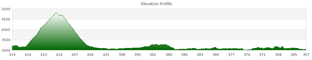
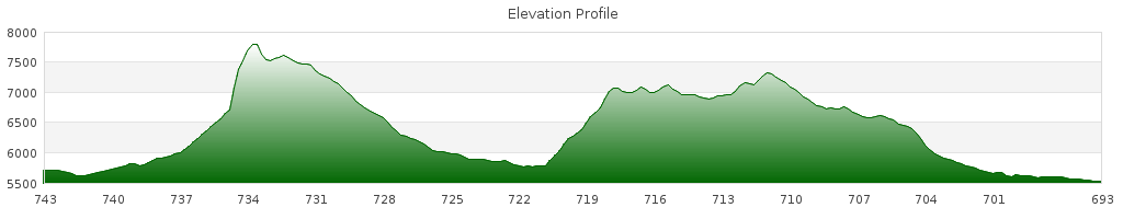
With breakfast, I made a bowl of almond pudding – a bit of bonus energy in preparation for Fleecer Ridge. Fleecer Ridge is probably the most talked about landmark on the route – a quad trail goes straight up it for .3 miles of 38% a grade, then .6 miles of a 16% grade. It’s a hike-a-bike for northbound riders and all but the most daring southbound riders.

My fear for the day was my rear tire. It has had four flats in the past three days. It’s because an old tire boot attracts sand and gravel, which consistently wore through my inner tires. How long will it last today?

We started on a few miles of pavement. Where the main route turned off road, we could have went straight and bypassed Fleecer Ridge. If I chose that, I know I’d regret it. So we turned onto gravel and started gradually climbing. I was relieved my tire held air beyond the first few minutes. It gave me slightly more confidence.

The road became slightly steeper, but I felt very good. Most days, I’d be far behind Mathieu, but today I stayed right with him.

We climbed and climbed through lush forest. Eventually we came to a dead end. Where was Fleecer Ridge? Mathieu pulled out his GPS and I consulted the map. It looks like we missed a turn. But which turn? We backtracked slowly so as not to miss our turn again.

At our wrong turn

Here is where we went wrong – we continued up to the right instead of turning left.

Creek Crossing

After a creek crossing and short amount of rough trail we finally saw the beast. I believe Mathieu said something to the effect of: “That’s impossible.” We’ll see.

Looking up Fleecer Ridge

Once again for emphasis: .3 miles of a 38% grade, then .6 miles of 16%.

I looked at my watch and saw that it was just past 13:00 when we started pushing…

It was impossible to push straight up, so we made long switchbacks in the grass. We made hardly any vertical distance, though. After struggling a while, we decided to both push my bike. One pushed from behind, the other kept the bike upright while also pushing. We pushed a 20 feet then rested over and over again until the trail “leveled out.”

We went back down for Mathieu’s bike. With his BOB, it was much harder. After a while we got smart and carried the bag, trailer, and bike separately up the mountain. Too much of our energy was wasted trying to keep the bike upright.

When we scrambled back up to my bike, we went back to pushing our steeds separately. It was nowhere as steep as before, but still very tiring. As we pushed, I kept seeing false peaks. 100 more feet! 100 more feet! 100 more feet! It went on for .6 miles.

Fleecer Ridge

We summited Fleecer Ridge at 15:00 – 2 hours to travel 1 mile! And we had 35 miles and a Continental Divide crossing before Butte.

Fleecer took a lot out of me – Mathieu wasn’t happy either. I wanted to eat something, but knew time would be tight, so I munched on Pop-Tarts. They’re amazingly fast and easy to eat!

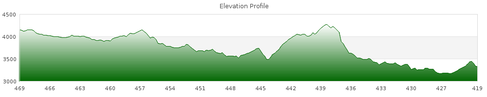
We enjoyed 10 miles of descent before…another FLAT TIRE. I changed it quickly and added more duct tape to the tire boot. At this point, the tire bulged where it was torn and the duct tape showed through. There was absolutely nothing protecting the tire from sharp rocks and sticks.

So now I’m tired from Fleecer Ridge, hungry from a lack of lunch, lacking confidence in my tire, and pressed for time getting to Butte. I was starting to lose it mentally.

At the bottom of the descent was I-15. Mathieu and I stood there and looked at our options. I could ride along the highway and get to Butte faster and with less a chance of a flat, hitchhike to Butte, or continue on the route. I didn’t want to hitchhike or ride on the interstate – on the main route we continued.

Right from passing under the highway, we climbed. It was a grueling, steep, four mile ascent. Mathieu saw I was struggling and waited for me to catch up after less than a half mile. He said something that unnerved me further – “We might not make it to Butte tonight.” Great…we might be camping right up on the Continental Divide (dry) and I have hardly any water. Add that to my fragile psyche.

I tried to climb but completely broke down. I was frustrated with myself, my situation, and didn’t want to climb further, but I couldn’t stop. My legs no longer could push the pedals, so I got out of the saddle and tried to sprint. My legs ached…my face contorted like I was eating something sour…I breathed in short whiny bursts. Finally I stopped to walk.

I have been close to breaking down in the past, but never truly got there. Right now, I was there. I stopped walking and let the tears flow. I sobbed for a few minutes. I felt much better after it was out of my system. I rode/pushed until I finally reached the top of the climb. Now, only a few short rollers before a long descent into Butte.

I was still low on energy, so I positioned an open bag of MMs at the mouth of my rear pannier. I munched on them until I made it to the start of the descent into Butte.

Downhill to Butte

What a relief. Now I new I’d be able to make it the last 12 miles into town. I took it slow to avoid flats. The road turned into pavement and I could go faster. The bulge in my tire noticeably oscillated my bike.

IMGP1792

It was 20:15 when we reached the outskirts of Butte. With three miles to go, my tire went flat AGAIN! “This will be my fastest change” I told Mathieu. I timed myself: 10 minutes from flipping the bike to riding again. Not too shabby!

We rode into town right as the sun was setting. Now we had to find a place to stay. It was a saturday night on 4th of July weekend, but luckily the first place we found had wifi, a lobby computer, breakfast, vacancy, and wasn’t too expensive.

We walked to a Walmart, ate at the Subway, and then shopped in the store. It was good to be in town. It was good to have Fleecer Ridge behind me. Better yet, there are bike shops in town so I can replace my cursed tire.


Stats
Distance: 50.76 miles
Ascent: 5766 ft
Descent: 5951 ft