Author Archives: dave

Bannack to Wise River

July 02, 2010 – 58 miles

Before continuing on route, we visited the historic Bannack ghost town, an old gold mining town. I would have loved to go to a river and spend a day panning. I’ve always been drawn to the idea of prospecting. Just ask my grandmother – she’ll tell you that my 6 year old self wanted to be a “mountain digger.”

Bannack, MT

Bananck, MT

Today we’d be riding entirely on pavement – that lessened my fear of flat tires. Regardless, 10 minutes into the day’s ride, my tire went flat. I decided to patch it on the spot instead of replace the tube. I wanted to have at least one good spare tube to avoid having to patch one later in the rain.

Though I was riding on pavement and going downhill at a time, headwinds made it a slow struggle. After 20 miles, I saw Mathieu’s bike parked at the first restaurant en-route. He was inside talking with a Canadian named Michael who was riding southbound on the Great Divide in a leisurely manner. I joined them and ordered some food.

After lunch, just as we started a 7 mile climb, it started dumping cold rain. Will it be a quick shower or a long downpour? To don the rain pants or just a jacket? Decisions…decisions, but there is no right answer. If I put the rain pants off, I’ll get soaked in sweat. But if I leave it off, I’m going to be cold and wet.

IMGP1782

At the top of the climb, it stopped raining and the sun came out. This was great – 35 miles of pavement down 2000 feet from here to Wise River.

Along the way, I had the urge to have a squat. I couldn’t find a suitable place, though. I was in the middle of the woods, but I couldn’t find anywhere where I wouldn’t have to walk a half mile from the road to not be seen. When I eventually stopped, I found out bare ass in the Montana woods is prime target for hungry mosquitoes. Believe me when I say they love their white meat.

After feeding half of the state’s mosquito population, I continued onward to Wise River. A strong headwind picked up for the last few miles. A threat of rain gave me an energy boost to get to the shelter of the town ASAP. Timed perfectly, I arrived within a minute of it starting to rain.

We ate dinner in the Wise River Club and rented a cabin for the night – it looked like rain and cold were blowing in overnight.

Better get a good rest tonight. Tomorrow we conquer the infamous Fleecer Ridge.


Stats
Distance: 56 miles
Ascent: 3183 ft
Descent: 3298 ft

Lima to Bannack State Park

July 01, 2010 – 80 miles

We ate another filling breakfast at Jan’s before leaving. On our mind was the road ahead. Our maps warned that the route was impassible when wet. Yesterday’s mud fiasco was still fresh on our minds. We studied the weather channel and decided not to detour along the highway.

Leaving Lima

The first 10 miles were slightly downhill and with the wind along the highway’s frontage road. They flew by! Then we came to where the route turned off-road. Last chance to stay on pavement. The next 50 miles are very remote and impassible when wet. We continued anyways and I’m glad we did.

IMGP1756

We rode through a narrow canyon right along a river. I loved it and stopped often for pictures.

IMGP1758

IMGP1763

Throughout the canyon there were loads of amazing dispersed campsites. We met a geologist who explained why volcanic clay was so sticky and advised at what point along our route the roads were safe when wet. So now we had a destination to reach before rain fell…or else.

IMGP1764

IMGP1768

We reached open area and rode northwest toward the Medicine Lodge-Sheep Creek Divide. Along the Continental Divide we saw storm clouds brewing. We weren’t past the volcanic clay yet and couldn’t afford to get caught in the rain. We pushed hard for 12 miles while slowly climbing. Mathieu and I rode parallel in silence. I struggled and struggled and craved a few minutes to rest but I didn’t give in.

The last half mile to the divide was the worst. As much as I wanted to reach the top without putting my foot down, I couldn’t. The rocks were too loose and the slope too steep.

IMGP1770

At the top the geology guy drove up and reminded us where the safe zone was. I wasn’t concerned since we had a nice downhill for the next 20 miles. The first mile was terrible, though. Extremely steep and loose – more than the road up. I had to dismount during some sections when I couldn’t keep my speed under control.

Then, as the grade lessened, I let myself go faster. I wasn’t paying attention to much beyond the next few feet in front of me. The rocks were still dangerously loose. I was nearly swallowed by huge 3-foot deep potholes in the road on several occasions. Usually I swerved just in time and avoided the worst of them. There was one that I hit that left me surprised my fork was still attached to my bike. It was that rough.

The roads finally improved and we let the downhill and helping wind take us away. It started raining on and off and we decided to stop for lunch. Tortillas and tuna suppressed my hunger.

A few miles after lunch, my tire went flat again. I changed the tube, but since it was raining and muddy it was nearly impossible to keep the sand and gravel out of my tire. The tire boot was failing badly now.

Five miles later – another flat. As I changed this one, a fellow on a motorcycle drove next to me. I was in no mood to talk, but he didn’t notice. He pulled out a microphone recorder and documented his meeting me. He thought my flat was caused by the tread being very worn.

Before he left, I asked him to let Mathieu know I had another flat if they met ahead. I pumped my tire in silence and rode onward, nervous about how long it would be until my next flat.

Luckily, I caught up to Mathieu without incident. He was stopped outside the guest ranch we set as today’s destination. No one was home, though. We couldn’t do anything but ride further. 10 miles ahead was Bannack State Park.

I was exhaused from 70 long miles, anxious about my flat tire, and frustrated about having to ride further. I didn’t know it at the time, but between us and Bannack SP was the “Bannack Bench” – a watershed divide. 5 miles up and 5 miles down.

The roads were horrible – unevenly dried mud. There were two relatively smooth tire ruts to ride in. It got late in the evening and the bugs came out. I wasn’t fast enough to escape the mosquitoes. Then, along came a car head on. There was the tire tracks were the only place I could ride, yet the oncoming car didn’t move out of the way. We played chicken before I was forced out of my rut and onto the unrideable portion of the road. That pissed me off. I had to dismount my bike to get out of the car’s way…

A few minutes later I crested the watershed divide and enjoyed the descent to Bannack State Park. We set up camp, ate a quick meal while under mosquito attack, then hid in the tents the rest of the night.

What a day it was – the threat of impassible roads, anxiety of flat tires, and unexpected extra mileage.


Stats
Distance: 80 miles
Ascent: 4474 ft
Descent: 4963 ft

Upper Lake CG to Lima

June 30, 2010 – 63 miles

I found no water in the tent this morning, so I started cooking breakfast. Again, suddenly, another rain shower came in from over the Divide. I sheltered in the tent and packed what I could while waiting for the rain to let up.

Soon the skies were clear and the sun was out, so we packed and rolled out of camp. The road was muddy, but rideable. A few miles down the road we passed the tiny “town” of Lakeview (it was more of a cluster of houses). A half mile later, I realized the mud was starting to stick to my wheels. Each rotation added another layer of mud on top of the previous until it clogged my fork, rack, and chainstay. Forward motion became impossible.

IMGP1741

IMGP1742

I cleaned off my tires as best as I could and pushed forward. A few rotations later, the wheels – again clogged with mud – no longer turned. We decided to turn back and wait in Lakeview for the roads to dry. There was a ranger station where we maybe could de-mud our bikes.

It was easier said than done. The sun and mosquitoes came out in full force, making for a miserable experience worse. Mathieu detached his trailer and struggled to push his bike back in town. I, with my racks, had a harder time. I decided to push the bike off the road through waist high grass to avoid the mud. It was wet, itchy, and full of bugs. I applied DEET and they more-or-less ignored me. Mathieu, on the other hand, suffered the full effect of those blood suckers.

After what might have been an hour, we made it back to the town and the forest service station. We found a hose to unstick the mud. The locals said the roads dry out very quickly, so we waited (I snacked on an early lunch).

By 11:30 we were ready to try the roads again. I was in no hurry as I didn’t want to push back again. With 55 miles to go at 11:30, I knew this would be a tough day.

We chose our lines carefully and stayed mud free. What a relief.

IMGP1744

We crossed a big empty basin and the miles dragged slowly on. The elevation profiles showed this section to be mostly flat. On the contrary, it was many short climbs and descents (see detailed elevation profile below).

We stopped for lunch after battling straight into the wind for a number of miles. Mathieu tied his tent to a fence post to let it dry. The wind was so strong that it acted as a kite. I worried that the fabric might tear, but it never did.

Riding after lunch was no different that before. A strong headwind with small hills to climb.

IMGP1749

IMGP1751

Finally, after many slow miles, I finally spotted Lima, MT in the distance. Better yet, it was downhill!

Looking down to Lima, MT

Just as I started descending I realized my rear tire was going flat…with one mile to go! I rode on it as long as possible until the bike felt too wobbly. I pumped it up and rode the rest of the way into town on a very splashy tire.

Mathieu rented a motel room for us for the night. I agreed that we deserved the luxury after such a trying day. Not to mention that it had been about a week since my last shower. We cleaned up and went to Jan’s for dinner. It was a feast! After a huge burger, chocolate milkshakes, and lots of soda, we were stuffed. So much that it hurt me to walk. (The half-gallon of soda might have been excessive).

Afterwards, I repaired the flat tube. The tire boot that was supposed to close the tear in my outer tire was gathering dirt which rubbed holes in my tubes. I reinforced the tire boot with duct tape. Hopefully it will hold for 3 days until Butte.


Stats
Distance: 57 miles
Ascent: 2654 ft
Descent: 3036 ft

Warm River CG, ID to Upper Lake Campground, MT

June 29, 2010 – 65 miles

It was extremely wet when I woke this morning. Not from rain, but dew. We hung our gear in the sun as long as possible before packing it in on our bikes. The trail today started right in the back of our campsite on an old railroad bed. It started on a gentle but noticeable incline following a river upstream.

IMGP1719

IMGP1720

After a few miles the trail leveled out and turned away from the river. The rocky trail became a narrow rut filled with very loose sand. It took a lot of concentration to keep the front wheel from turning and digging into the sand. While concentrating on the next few feet ahead of me, I saw Mathieu’s tire marks and various animal tracks. Bear tracks! In the sand, on top of Mathieu’s tire marks, were bear tracks! That got me singing real quick. From then on, I nervously glanced through the forest for any signs of them – it certainly didn’t make riding in the rut easier.

IMGP1728

IMGP1729

I eventually caught up with Mathieu and we vented our frustration with the condition of the trail. We decided to parallel it on a road. It was still very sandy, but we didn’t have to worry about the rut. Now, we had to deal with washboard…

We reached a main road and searched for places to eat. Mathieu, who always had a taste for pizza, saw a sign for a pizza place so we rode over. Closed! Of course the restaurant we found was only closed on Tuesdays.

We rode on and found another place to eat. I had a a large bowl of spaghetti and a grilled cheese sandwich with large quantities of Coke. We restocked supplies at a local convenience store before continuing on. I bought a large bag of peanut MMs to snack on. I doubt they’ll last too long.

A few miles of pavement lead to a dirt road that was, according to the sign chained across it, closed. We passed through anyways and saw why it was closed. A few sections had been washed out. It was like being on a roller-coaster, riding (sometimes pushing) through 5-foot deep trenches cut across the road. It tested our skill trying to pedal loaded bikes up the opposite sides of the washouts.

Beyond that, the road was very fun. It was covered in large boulders and consisted of lots of short up and downs. I enjoyed the technicality of having to plan a path through the obstacles while trying to maintain momentum (on my dump truck of a mountain bike).

That road ended on pavement again. I settled on my seat and pressed through more miles. My saddle sores acted up with vengeance!

IMGP1730

We turned off-road once again and started climbing to the MT/ID border at Red Rock Pass, which is a Continental Divide crossing.

It certainly wasn’t a difficult climb by past standards, but my legs were nearly dead. With the help of MMs I eventually made it to the top.

Leaving Idaho

There wasn’t much of a descent on the other side of the pass. The road turned to ball bearing-type gravel, which made the bike skiddish at higher speeds.

IMGP1736

The road hooked left and I faced the mountains that made up the Continental Divide. They were simply stunning! I love Montana already!

IMGP1737

I pressed onward. Our campground destination was only a few miles ahead. But I was extremely exhausted. I put a foot down to rest a minute. Not 20 seconds later, a truck drove past with two very good looking girls in the cab. They waved and cheered out the window, but didn’t stop. Why did I have to stop right then? They had to see me right as I was giving up…

They my mind started turning. Maybe they were staying at our campground. That was all the motivation I needed to mount the bike and ride the rest of the way without break.

IMGP1740

Unfortunately, when I got there they were nowhere to be found. Damn…

I gathered some water and started cooking dinner right as some menacing clouds passed over the towering Continental Divide. I donned my rain jacked, not for the impending storm, but for the hoards of mosquitoes. They sounded like the buzz of high voltage power lines.

A few minutes later, the rain came with wind and lightening. I hunkered in my tent for a half-hour until it passed. I quickly finished dinner and secured my gear under a table wrapped in a poncho. Once again, it started dumping rain. It continued the rest of the night.

The wind was the scariest part. I’ve never camped in this tent in high wind conditions. Mathieu was worried and called over to make sure everything was fine. It was, luckily.

Its funny how the mind dwells on certain things. We were in the heart of bear country and yet I didn’t once worry about bears – only the wind. (Wind can’t bite my head off, can it?)

As it was raining, I realized I had to pee…bad. There was no way I could hold it six hours until morning but now way I was getting out of my tent, though. So I managed to position my body that I could pee out into the rain fly without flooding the inside of my tent. Mission accomplished!

(note to self: bring a pee bottle next time)


Stats
Distance: 65 miles
Ascent: 3588 ft
Descent: 2311 ft

Colter Bay, WY to Warm River Campground, ID

June 28, 2010 – 54 miles

Started with the normal packing routine this morning. I treated myself with macaroni and cheese for breakfast, though. Mathieu noted that pasta for breakfast makes me a real cyclist.

In the back of my mind I realized that if I wanted to, I could end my trip right here. Throw the bike in the car and drive home – no more saddle sores, no more painful miles, no more uncomfortably cold nights. The same thought came across my mind a few weeks ago when I saw my sister in Como and Frisco. Quitting was never a serious consideration, but such an easy opportunity to do so was…a temptation?

My mom and sister left the campground before we did. I was sad to see them go, but I have to continue on. I guess it is only three or four weeks to Banff. Having made it this far, I’m physically and mentally capable of completing the ride, but I don’t want too think to far ahead.

As I was packing my gear, Auke told me he decided he would ride into Yellowstone to take photos. He’d also ride into Glacer National Park. It was unlikely we’d meet on the route again. I suggested that maybe we’d see each other in Banff or Jasper. But the chances of that are every slim.

I noticed Auke was fiddling with his bike as I continued to pack. I could tell he was killing time and waiting for Mathieu, who was at a computer updating his blog. After a while of Mathieu not returning, Auke decided to leave. Strange that after a month of riding together, he wouldn’t wait to say goodbye. Although they do live relatively close together in the Netherlands. Maybe they’ll catch up then.

Mathieu returned from the his blog updating and I told him we were not a group of two.

Somewhere along the line, Mathieu realized he couldn’t find his map. After a lot of searching, we decided it was gone. He and I would have to stick together for the next few days.

We rode on the RV-filled US 285 for 15 miles out of Colter Bay. I don’t like holding up traffic when riding on busy roads, but after a few very close vehicles I decided taking the lane was necessary for my safety.

Tetons across Jackson Lake

IMGP1712

We turned onto a dirt road and encountered some short ups and downs. Some of the down sections were extremely rocky. I’m amazed that my bike has made it this far.

Eventually the road turned into a washboardy-gravel road that was ever so slightly downhill. The miles passed surprisingly easy. We rode past some sort of tour group who were riding on horse-drawn Oregon-trail style wagons. One of the guys yelled to us, “You’re doing it the hard way.” That’s right, we are. Proud of it, too!

A few miles down the road, the forest cleared and revealed a view of the backside of the Tetons.

IMGP1713

IMGP1714

Suddenly, the road turned to pavement. What a great surprise! Soon after, we saw a sign for the Squirrel Creek Guest Ranch – Tour Divide racers welcome! We had to stop by and say hello.

We found the ranch owner mowing his yard. We were welcomed inside and drank a few cold cokes. The place seemed more like a personal house than a guest ranch, so it felt odd being there. Our host offered to turn on the range and make us grilled ham sandwiches, but Cokes were sufficient.

Forest turned to farmland, and it looked like I could be riding in rural Ohio.

Tetons from Idaho

A few more miles and we made it to the Warm River Campground. The host of the campground was very friendly and offered us his favorite spot on the property. We settled in for the night.

Warm River CG

Stats
Distance: 61 miles
Ascent: 3130 ft
Descent: 4669 ft

Elevation Profile Maps

Sorry for this interruption of my regularly scheduled sporadic journal entries, but I have something cool to share.

As you may have noticed from my journal entries so far, I often observed (complained about?) a huge difference between the map elevation profiles and actual ascent/descent on the ground. Well, I wanted objective data to find out if this was just my weary mind over-exaggerating the climbs or the elevation profiles being overly-smoothed.

So I plotted the route on Google Maps and wrote some code to show precise elevation gains/losses for any section of the Great Divide. As a cool addition, the application also shows an elevation profiler for any selected section. Check it out at eatsleepridegreatdivide.com. If you’re planning on riding the Divide this year or racing the Tour Divide, you may find it useful.

*Special thanks to Scott Morris and TopoFusion for the uber-detailed GPX data.

Colter Bay Rest Day

June 27, 2010

Last night was very cold in our wall tent. Our body heat escaped into the cold air circulating below our cots. Tonight, I’ll sleep on my mattress pad on top of the cot.

Auke, Jenn, and mom woke very early and drove to take pictures of the Teton barns. Mathieu and I slept in until 8:00.

We assumed our normal rest day routine: bike maintenance, replenishing energy stores, updating journals and blogs, etc. I was especially happy to unload the rest of my spare gear and get a new chain. The old chain had stretched a few inches! Luckily my cassette accepted the unstretched chain without skipping.

DSC_2232

My mom and sister came back from a hike and we went to a gravel beach to eat lunch. I enjoyed the crackers, cheese, and Blue Moon.

DSC_2264

I decided to take a swim in the lake. It’s been a while since my last proper shower, but I thought this might count as one. The water was numbingly cold, but I managed to force myself all the way in eventually.

DSC_2255

Lava Mountain to Colter Bay Villiage

June 26, 2010 – 47 miles

I woke up and cooked breakfast on the porch of our grizzly cabin. We thought the restaurant from last night served breakfast, but it did not.

Just before leaving, rain moved in. No one wanted to start the day wet so we waited for it to pass. I grabbed a cup of coffee and by the time I finished it, the sun was out again.

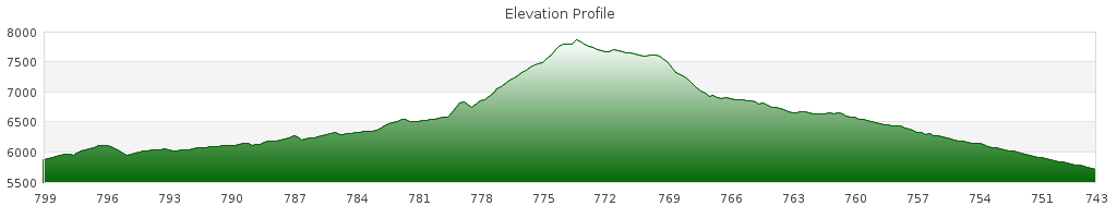
We rolled onto the busy US 285 heading for Teton National Park. Quickly (but not unexpectedly) Mathieu and Auke rode ahead out of sight. I’m in no hurry today. It’s 45 paved miles to Colter Bay. Plus, my mom and sister are coming to visit in Colter Bay. They’ll be passing me sometime today.

At first, there was a large shoulder to ride on, but an hour into the day it ended. I literally stopped riding and said “oh no.” But no one was there to hear my dread – except maybe the grizzlies that we’ve been constantly warned are in the area.

IMGP1706

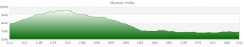
Without a shoulder, the miles up Togwotee Pass would certainly not be the most relaxing of our journey. Not with the constant flow of construction vehicles and oversized RVs passing fast and close.

No use dwelling, though, so I continued. The few un-shouldered miles were not as bad as I expected. Most traffic passed at a reasonably safe distance or waited behind me until being able to do so. The road condition was the issue. The pavement was cracked and crumbling along the sides, which made for bumpy sections when traffic didn’t allow me to swerve into the center of the lane.

It seems odd to be complaining about cracked pavement after riding so many miles of rock, gravel, and washboard, but the fundamentals of Buddhism explain it. Attachment (or desire) is the cause of all suffering, according to Buddhist philosophy. I have become attached to the idea of pavement being equivalent to smooth/easy riding. That is what I desire (really, who doesn’t?), but since it is not what reality gave me, I suffered. To overcome this suffering, I have to detach from wanting a smooth ride. That way, I can accept the bumps instead of despise them.

As I climbed up Togwotee pass I often looked behind me to see if my mom/sister were coming. I was also excited to see them and the food/goodies they brought. Togwotee pass is a continental divide crossing, but there was no sign at the top. I knew I was at the top (as opposed to a false summit) by a glorious sign that read: “6% Grade Next 17 Miles.”

IMGP1709

IMGP1708

It was cold and windy at the top. I readied myself for a cold descent. On came the rain jacket, pants, and gloves. I started the fast and cold descent. I kept my legs turning, not to increase speed, but to keep the blood circulating. Doing an easy 30 mph, I took the center of the lane, not letting cars pass until I thought it was safe. I wasn’t going to risk being run off the road at that speed.

A few miles down the road, I hit a traffic jam. There was construction ahead and only one lane of traffic could pass at a time. I was transported through a few miles of construction in a pilot car. Why couldn’t this have happened on the way up the pass?

I asked my driver about bear in the area – people seem to like talking about them. He’s been charged multiple times and carries spray and a .44 (when off of work).

After the construction section, I unloaded my bike and rode onwards. The first thing I noticed was that the grade of the road wasn’t nearly as downhill as before.At times I thought I was going back uphill. Surely, I wasn’t 17 miles from Togwotee, so this was an unpleasant surprise.

After a few miles I was soaked with sweat for not removing my wind layers. Of course, the road started descending again!

I heard quick taps of a familiar car horn. My mom and sister had finally caught me. They drove past and pulled off the road. I hugged my teary mom while my sister, though silent representation behind her back, informed me that my mom freaked out when they first saw me.

DSC_2085

After the hellos, we got down to business – what goodies did they have in the trunk? I enjoyed a turkey sandwich, MMs, and Coke.

As we ate and talked, Mathieu and Auke arrived. I really thought they were ahead of me. They followed the main route where it bypassed sections of US 285. They missed the traffic, but got stuck in mud and snow by Brooks Lake. The mud clogged their forks and fenders making forward movement nearly impossible. I’m glad I braved the traffic.

We chatted over food for a while before riding onward – less than 30 miles to Colter Bay. Over the next 8 miles, I enjoyed very fast descents until bottoming.

DSC_2096

After so much descending, my legs no longer wanted to pedal. But I was on flats now and had a headwind, so laziness wasn’t an option. Instead, I munched on handfuls of peanut MMs from Pinedale. It helped, but only slightly.

After paying and entering Grand Teton National Park, the shoulder which had re-appeared, re-disappeared. The rest of the day, the roads were narrow and lacked a shoulder. Still, traffic was generally slow and passed safely.

When I made it to Colter Bay, I found four familiar faces waiting on me. After a lot of “it doesn’t matter to me” and “whatever you want,” we decided to rent a wall tent for the four of us. We emptied our belongings into our temporary home and went for an overpriced meal at the restaurant.

Afterwards, it was near sunset so Mom, Jenn, and I drove to a scenic lookout point. They wanted to take pictures of the mountains and any wildlife they could spot.

It was a nice sunset, but I didn’t like the idea of going somewhere to see it. I observed others at the pull-out. Drive up, take a few pictures, drive off. What good are those pictures? I doubt they are worth the proverbial 1,000 words. There is no story or experience to tell about it.

Instead of snapping photos, I enjoyed the sunset in a different sense. When the bottom of the sun touched the top of the mountains, I closed my eyes and felt the warmth on my face. Slowly, it faded and the day was done.


Stats
Distance: 52.64
Ascent: 3282
Descent: 4226

Whiskey Grove CG to Lava Mountain Lodge

June 25, 2010 – 56 miles

As we ate this morning, a friendly squirrel joined us at the table.

Hungry Squirrel

IMGP1678

IMGP1681

Before we left, the Montana Conservation Corps showed up to cut down trees affected by the pine beetle. We talked to them for a bit and got an email address of a guy to call when we get to Helena. He may offer us a place to stay while in town!

We turned out of the campground and immediately got stuck behind a cattle drive. One of the ranchers on horseback led us through the middle of the herd. There was crap all over the road, which flung onto our legs, bikes, and gear.

On the side of the road there were people riding horses. They were tourists watching the rangers herd the cattle. We were part of the show, I guess. It made me proud knowing I wasn’t a part of some guided tour. I was experiencing the real deal.

IMGP1683

IMGP1684

We climbed 1,000 feet over 8 miles to a properly named location – Mosquito Lake. All I could think about is how deceptive our elevation profiles can be. 1,000 feet over 8 miles is an easy grade, but that’s not what my legs were telling me. The road went up, then down, then up again. It may seem nice to have some descents thrown in to the mix, but I didn’t think so. It’s terrible to crest a hill and see a descent leading directly into another, even taller, hill. Sure, momentum from the descent carried me part of the way up the other side, but given rolling resistance, air resistance, and braking to control the bike, it is minimal.

IMGP1685

Mathieu waited at Mosquito Lake & Auke rode ahead. He couldn’t stand the mosquitoes. Our next point of reunion would be Union Pass.

The 19 miles were roughly divided into thirds – climb, descend, climb. The first two were pretty easy and enjoyable. I struggled through the last part. The road degraded to loose gravel and a headwind developed.

IMGP1688

Near Union Pass, WY

At the top of the pass (also a continental divide crossing), I ate my standard tuna and tortilla lunch. Just afterwards, we met our first SoBo Great Divide through-rider. He was from the same town as Matthew Lee. I didn’t connect the dots, but when I talked to Matthew in Rawlins, he told me to say hello to a slow-tourer from his hometown that he knew. It wasn’t until later in the evening that I realized who we met was Matthew’s friend.

Afterward, we gradually climbed for a few miles to the top of a mountain (counter-intuitively, it was higher than the divide crossing we just topped). I stopped to filter fresh snowmelt on the side of the road.

IMGP1694

A fast 5-mile descent through forest followed. Then a short ascent, then another very steep descent along tight switchbacks. The view included the Tetons in the distance.

IMGP1696

IMGP1701

At the base of the descent, we met up at a closed gas station along US 287 and raided a soda machine. As we sat, a huge Greyhound bus sized RV pulling a trailer large enough for two cars pulled up. We laughed at the dichotomy of our travelling styles and setups.

Earlier in the day, someone told Mathieu the place we were thinking of staying was 5 miles from where we were then resting. While Mathieu and Auke were waiting for me, another motorist said it was 8 miles. So I put it in my mind that there were only 8 miles (mostly uphill, into the wind) between me and a place to eat and rest.

I went slowly. As my legs tired, I put more weight on my sore butt. The sodas I drank were bubbling in my stomach causing slight uncomfortableness. Regardless, the 8 miles came and went without sign of the Lava Mountain Lodge.

Another 2.5 miles passed before I arrived. Mathieu and Auke were already in the bar having a beer. I enjoyed a very tasty Blue Moon. After drinking it and struggling through an awkward conversation with a very intoxicated man, I escaped the bar. I went to check the “grizzly cabin” we rented for the night.

I found that a family of travelling cyclists had shown up. They had started their trip in Colorado and were riding to Seattle. Erin & Claren are college students like myself. Bretten, the youngest, is still in high school. It was refreshing to meet some folks my age on their own bicycle adventure.

The way their trip was planned, it did not seem like there was much room for flexibility. They had lodging reservations tonight 50 miles ahead in Colter Bay. They had lost a day of travel due to their father having a kidney stone.

It was 18:30 already and the roads were narrow and busy with RV traffic. I don’t know if they made it all the way tonight or not.

IMGP1703

IMGP1705

The family left and I rode town the parking lot to find our cabin for the night. I saw one on my right with a bike outside and turned to go to it. The road was sloped away from the cabin and covered in loose gravel. I didn’t turn hard, but just enough to make my wheels slip out from under me. Body meet ground.

This time, there was a small audience to enjoy my comical fall. It was the drunk guy from the bar and a lady sitting outside her cabin. “Well, that’s embarrassing,” I said. It didn’t hurt, so I got up and rode on. I realized the cabin I was riding toward wasn’t ours. I changed course to backtrack.

Again, my wheels slid from under me and I went to the ground. This time it hurt. My knee and hip absorbed the impact. I layed on the ground in pain, cursing. The lady at her cabin asked if I was OK. I half-lied and said yes.

I walked the rest of the way to the cabin…just to be safe. So far, my only real falls occurred in parking lots.

The grizzly cabin wasn’t much more than a glorified shed. It had a table, two bunks, and a heater. After getting settled, it was time for a long awaited dinner. I ate a burger, and a hot fudge brownie sundae.

Afterwards, I cleaned the cuts from my fall and washed up in the bathroom. They had showers, but I opted against one – it cost $0.25 for 40 seconds!

Back at the cabin, I climbed into one of the top bunks & into my sleeping bag. Although it was cool outside, the cabin was extremely warm – especially up on the top bunk. I had one of the worst night’s sleep in a long time.

Boulder to Whiskey Grove Campground

June 24, 2010 – 47 miles

The general thought for the morning was to eat either in Boulder or Pinedale (an hour ride away). I woke up early, took a shower, and cooked my own breakfast. Eating at restaurants often gets prohibitively expensive.

Mathieu left for Pinedale before us. It was odd because he always waits to leave together. We figured he wanted to Pinedale early to look for a canister of bear deterrant a TD racer said he left at a motel.

If the TD racers are dropping their bear spray here, it surely means we’re entering or already in bear country.

Auke and I left a little later. Somehow a bungee cord wrapped itself into his rear wheel and hub. A quick fix later, we were moving onwards to Pinedale. The 12 miles should have been easy, but were not. Yesterday’s long haul added a number of new saddle sores to my rear. Putting any weight on the saddle was uncomfortable.

In Pinedale, we met at the Subway. Even though I had breakfast two hours earlier, I had a footlong sub.

Our goal for the day was the Whiskey Grove CG, 35 paved miles away. It would be a cakewalk compared to yesterday, so we had time for shopping in town. I went to a large grocery store and replenished my food supply. For once I did not buy too much food! Next stop was an outdoor shop where I replaced my water filter. Even though I was not overloaded with food, I was weighed down by two water filters AND extra parts.

Two more days until I meed my mom and sister in Colter Bay and unload more spare gear.

Auke and I left Pinedale together. Mathieu stayed behind for computer time in the library. I’ve long since given up the hope of keeping this blog up to date.

The road led through a mountain valley. It really should have been an easy ride, but my butt hurt like hell.

Auke was waiting at the entrance to Bridger-Teton National Park. Among the warnings of bear in the area were notices that some campgrounds in the area were closed for tree removal, including Whiskey Grove.

We decided to ride there anyways since Mathieu knew to meet us. The campground was gated, but a NP ranger drove up. I asked to go in to filter water out of the Green River, which the campground skirted. It was alright, so I went in.

As I filtered, Auke talked to the ranger. The tree removers (the Montana Conservation Corps.) weren’t coming in the morning until after we’d be gone, so we were allowed to stay for the night. I appreciated not having to ride the 14 miles to the dispersed campsite at Mosquito Lake.

IMGP1674

We pitched our tents and cooked dinner (away from our tents) and waited for Mathieu. Either he saw the CG was closed and rode on, or stayed extra long in the library. The latter held true.

After my dinner of mashed potatoes, tuna, an apple, and MMs, I washed myself in the river. It was so cold that I could only bear going in up to my knees.

Before bed, we put our food and trash in the outhouse – finding a good tree to hang food is difficult.

The bear spray came into the tent with me this night. The MCC guys said they’ve had lots of bear encounters in the area.